Transforming Agricultural Management with Aerial Imaging
Modern Australian agriculture demands precision, efficiency, and data-driven decision-making. Whether you manage sprawling broadacre properties, productive vineyards, or diverse orchards, aerial imaging technology provides the insights needed to optimise operations and maximise yields. At Aerial Imaging Australia, we specialise in capturing high-resolution aerial data that transforms how farmers and land managers understand and manage their properties.
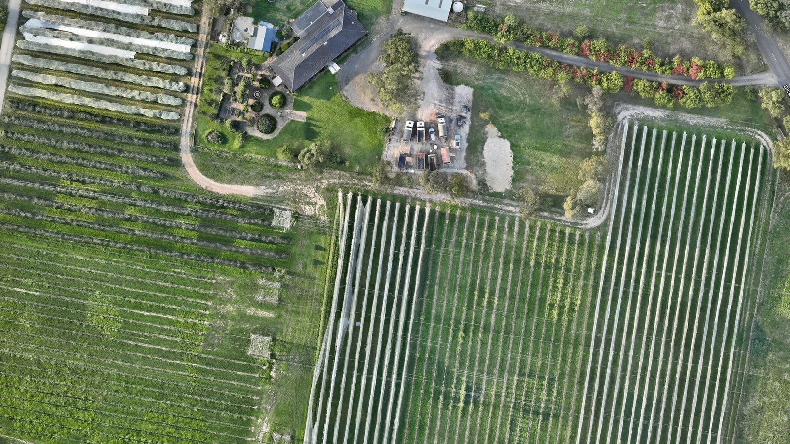
Aerial imaging uses drone and satellite technology to capture detailed imagery of agricultural land from above. When processed into orthomosaic maps and elevation models, this data becomes a powerful tool for planning, monitoring, and analysing every aspect of your farming operation—from crop health assessment to infrastructure planning.
Key Applications in Agriculture
Crop Health Monitoring
Aerial imaging reveals what's happening across your entire property that ground-level inspections can never show. Using multispectral sensors, we capture data that highlights crop health variations, pest infestations, disease pressure, and irrigation issues before they become critical problems.
- Early Problem Detection: Identify stressed areas weeks before they're visible to the naked eye
- Targeted Interventions: Treat affected zones precisely rather than blanket applications across entire fields
- Objective Assessment: Replace subjective observations with quantified health metrics across your crops
Precision Irrigation Planning
Water management represents one of the largest variable costs in Australian agriculture. Elevation data derived from our Digital Elevation Models reveals subtle topography that influences water flow, drainage patterns, and soil moisture distribution.
- Drainage Analysis: Understand how water naturally flows across your property to optimise dam placement and field grading
- Water Flow Modelling: Design efficient irrigation systems that work with natural terrain rather than against it
- Soil Moisture Zones: Identify areas with inherently different moisture retention requiring adjusted irrigation schedules
Yield Estimation and Tree Counting
For orchardists and vineyard managers, accurate inventory management is crucial. High-resolution orthomosaic maps enable precise tree and vine counting across entire properties, supporting harvest planning and yield forecasting.
- Accurate Inventory: Count trees and vines across large properties in a single flight rather than manual walking surveys
- Replanting Planning: Identify dead or missing trees to plan efficient replanting campaigns
- Yield Prediction: Correlate tree density, health, and spacing with expected harvest volumes
Property-Wide Mapping and Boundary Management
Orthomosaic maps provide a georeferenced, top-down view of your entire property with centimetre-level accuracy. This becomes invaluable for planning infrastructure, managing boundaries, and documenting property changes over time.
- Infrastructure Planning: Plan access roads, shelter belts, buildings, and water storage facilities with confidence in precise positioning
- Boundary Verification: Document your boundaries with photographic evidence and spatial coordinates
- Change Detection: Monitor seasonal changes, track progress of development projects, and verify completed works
How Orthomosaic Maps Support Agricultural Operations
An orthomosaic is a geometrically corrected composite image created from hundreds of overlapping aerial photographs. Unlike a simple aerial photograph, every point in an orthomosaic is aligned to true geographic coordinates, making it suitable for precise measurements and analysis.
For agricultural applications, orthomosaics offer unique advantages:
- Georeferenced Accuracy: Measure distances, areas, and positions with confidence for planning and compliance
- Year-Round Documentation: Create a permanent visual record of your property at peak seasons for comparison and historical analysis
- Integration with Farm Software: Import orthomosaics into farm management platforms alongside your GIS data and digital field records
- Agronomist Collaboration: Share detailed aerial views with your agronomist, consultant, or extension officer to support decision-making conversations
Elevation Data for Agricultural Landform Analysis
Beyond visible imagery, Digital Elevation Models (DEMs) capture the three-dimensional shape of your land. This seemingly simple data layer unlocks profound insights into agricultural potential and management challenges.
Elevation data reveals:
- Natural Water Flow: Understand how rainfall and irrigation water moves across your property to optimise drainage design
- Slope and Aspect: Identify micro-climates created by slope angle and sun exposure that influence crop performance
- Contour Lines: Generate contour maps for paddock design, terrace planning, and erosion management
- Cut and Fill Requirements: Calculate earthworks volumes for levelling or terracing projects with precision
Seasonal Monitoring and Change Detection
Agriculture is inherently seasonal. Capturing aerial data at key times throughout the growing season creates a temporal dataset that documents the progression from planting through to harvest. This enables you to:
- Monitor canopy development and closure in orchards and vineyards
- Track phenological stages across your property for harvest timing optimisation
- Document pest or disease pressure progression to refine future management strategies
- Verify effectiveness of previous management decisions through visual comparison
Integration with Farm Management Systems
Modern agricultural operations increasingly rely on digital farm management platforms—software that tracks inputs, monitor outputs, and supports data-driven decisions. Aerial imaging data integrates seamlessly into these systems.
Your orthomosaic maps and elevation data can be imported into platforms such as CVAS, FarmLogs, Granular, or your consultant's proprietary systems. This integration creates a unified information framework where aerial observations combine with ground-based sensors, weather data, and management records to paint a complete picture of your operation.
Why Choose Aerial Imaging Australia for Agricultural Projects
We understand Australian agriculture. Our team has extensive experience delivering aerial imaging services to orchardists, vineyard managers, broadacre farmers, and agricultural consultants across Victoria and beyond. We recognise that every property is unique, with its own challenges and opportunities.
When you engage Aerial Imaging Australia, you're partnering with specialists who:
- Understand Agricultural Workflows: We design our data capture and processing to integrate with how you actually work and make decisions
- Deliver Georeferenced Precision: All our products are accurately georeferenced to Australian coordinate systems for seamless integration with existing spatial data
- Provide Professional Analysis: We don't just deliver raw data; we work with you to interpret findings and support informed decision-making
- Operate Across South East Melbourne and Beyond: Whether you're in the Dandenong Valley, Yarra River region, or across Australia, we have the capability and experience to serve your needs
Agricultural aerial imaging is an investment in better information. The ROI comes through optimised input allocation, reduced waste, improved targeting of management efforts, and ultimately, increased profitability. Let us help you unlock the insights already present in your landscape.
Getting Started with Aerial Imaging
Whether you're considering aerial imaging for the first time or seeking to enhance existing monitoring programmes, we're here to help. Contact our team to discuss your requirements, timeline, and objectives. We'll recommend the most appropriate capture method, data products, and analysis approaches for your specific situation.